NO Reproduction in Whole or in Part, on ANY, and ALL of my Pages,
 Including Text and Pictures,
 May be made, without the express Written Permission
 of Web Editor, Doug Gent
© 2016


My Dad, Phillip George Gent
Phil Gent's (1912-1982)
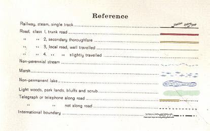
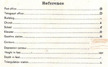
1927
  S.E.  Saskatchewan, Canada
Highway Map

SHOWING PART OF TOWNSHIP 7,
ALL OF TOWNSHIP 6, AND PART OF TOWNSHIP 5,
IN  PART OF RANGE 10 AND 12,  ALL OF RANGE 11
WEST OF THE 2ND MERIDIAN
 

Towns shown:
Midale
Holloway

Huntoon (top right)

Railroad shown is the CPR line,
plus the CNR is shown top right corner


Reference Key to
Roads, Railways etc.
Reference Key to
Buildings, Altitude etc.
Township Map
Showing Section #'s

`


My Quick Navigation Bar
Choose Your Next Step From Below

Return to Main Map Index PageClick this Icon to Return to My Home Index Page at any timeClick this Icon to go to Doug's Email Contact PageClick to Return to the Top of any PageClick to go to Next Map Page
Page last Updated on:
April 17, 2016
Created by Doug Gent
Jan 25, 2003

No Reproduction in Whole or in Part may be made
without the express Written Permission
 of Doug Gent

© 2016