|
|

|
|
 |
1927 S.E. Saskatchewan, Canada Highway Map Index |
 |
|
they will be slow to load but worth it if your looking for a particular Village, Town, Farm, School, or Church location from 1927 Please do not use ANY portion of the maps
I have added web pages Any photos, info, send it to me please.
|
|
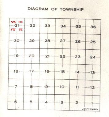
is exactly 1 mile square and is called a Section 36 Sections make a Township Correction lines are slight S turns in the North-South Roads, to correct for the curvature of the earth and the diminishing Longitude lines.
The Vertical Longitude lines |
|
Township 1 at the USA border, North to Township 8/9 boundary, or 48 miles North of the Boundary These are the North-South Coordinates It also covers Range 1 to Range 15/16 Boundary Range 1 is the Manitoba border and Range 15/16 boundary is 90 miles West of the Manitoba border These are the East/West Coordinates Using the Township map link above, you then can find the exact Section of land. Finally using compass coordinates the final 1/4 section, ex NE, NW, SW , and SE since the top of each map is always North the Right side East, Left side West, and bottom South. |
|
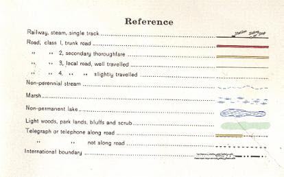
Roads, Railways etc. |
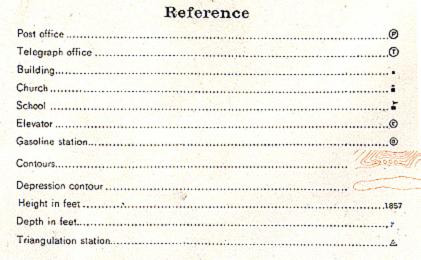
Buildings, Altitude etc. |
Showing Section #'s |
|
My Quick Navigation Bar     Quick Links Personal Family Pages SE Sask. Web Pages / Dad's 1927 Map of SE Sask. / Hillside Public School Estevan Collegiate Institute / Nor-West 1904 Newspaper / Terrace BC BC Tel Terrace District History / Contact page
No Reproduction in Whole or in Part may be made
Page created by
Doug Gent © 2016
|