My Genealogy and History Page of
 BIENFAIT
 SASKATCHEWAN
&  AREA
 1927 Map of the Area


 NO Reproduction in Whole or in Part, on ANY, and ALL of my Pages,
 Including Text and Pictures,
 May be made, without the express Written Permission
 of Web Editor, Doug Gent
© 2016

Want to add a link to my pages?
see my
Copyright Information Page
for the only Authorized Picture Link allowed.
All Pictures on all my web pages, are now Visibly Watermarked,
All my pages are now Right Click, copy and paste, disabled.
I ask everyone that enjoys free history sites,
to start policing these violations.
If we don't stop this, no one will donate pictures to me or anyone,
and we all loose.
If you see one of my pictures on facebook, etc.
tell them to remove it.


THIS IS A COPY OF A 1927 MAP 
SHOWING BIENFAIT AND AREA
I have added the Railroads and Highway numbers
I have also added the location of the Gent Farm
located 1 mile south of Bienfait on Highway 39

I have numbered these Coal Mines, and will try and name each mine eventually

1. The Eastern Mine
2. M&S (Manitoba and Saskatchewan)
3. Kingdon & Coates Mine
4. ?
5. M&S also?
6. ?
7. ?
8. ?
9. ?
10. ?
Green A top right corner= Lignite School
I have a small history book of this school
with names of some of the students.
The little booklet was produced in 1991 for
a Cairn and Plaque Ceremony marking the location of this rural school
It was built in 1906 on SE 1/4 of Sec 26, Tsp 2, Rge 6 W2
It was a one room wood frame building, built on a foundation of stone
 

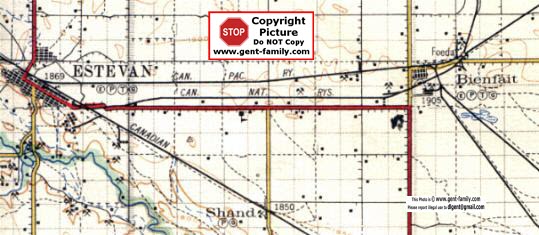
This Map is another view of the 1927 map
showing Estevan and Shand location
This is an original copy with nothing added
Key:
the P and T in the circles stands for Post Office
 and Telegraph Office respectively
the little E in the circle indicates an elevator in the town
the little G in the circl stands for a Garage in the town
The number 1905 under Bienfait
 is the elevation in feet above sea level
- - - dash line indicates road
small thin solid line is a Railroad
Heavy solid line is a Highway
little crossed pick and shovel symbols are Coalmine locations
Both of the maps above are left quite large on purpose
 

ORIGINAL MAP IS TITLED
  "WEYBURN"  Shown Bottom center
 SECTIONAL MAP # 20 shown in upper right corner
This map was produced by:
the Office of the Topographical Survey of Canada, Ottawa
in January of 1927, 
Department of the Interior
Hon. Charles Stewart, Minister; W. W. Cory Deputy Minister
is printed at the top of the Map
It is compiled from surveys by the
 Topographical Survey of Canada
 up to Sept 1924, and from information supplied by
 Dominion and Provincial Departments
 and by Railroad Companies
It is a Revision of map of Sept 1917
It comprises an area from Tatagwa
 just west of Weyburn, top left corner
to south of Ratcliffe (West of Torquay) bottom left
to East of Northgate in bottom right
to north of Manor upper right
or to be exact, Tp1 to Tp8 (south to North)
R1 to R15 (East to West)
West of Second Meridian
Original scale 3 miles to one inch
(note- maps above have been blown up
 before scanning, so scale isn't the same)
It is a very stiff paper, and quite yellow and brittle
_________________________
No where on the map is shown a copyright symbol
therefore I feel safe in reproducing it here.
The original price my Dad, (or his Dad), paid for it was 25 cents
If it was in a folder form, it was 50 cents 
Hope you enjoy it!


Return to Main Bienfait Index Page Return To Top Of  Page


No Reproduction in Whole or in Part may be made
without the express Written Permission
 of Doug Gent

Page created by Doug Gent © 2016
Created 2001
Revised Mar 24, 2008

Quick Links
Personal Family Pages
SE Sask. Web Pages / Dad's 1927 Map of SE Sask. / Hillside Public School
Estevan Collegiate Institute / Nor-West 1904 Newspaper / Terrace BC
BC Tel Terrace District History / Contact page

View the Feedback I get on my Bienfait Pages
Click Here