NO Reproduction in Whole or in Part, on
ANY, and ALL of my Pages,
Including Text and Pictures,
May be made, without the express Written Permission
of Web Editor, Doug Gent
© 2016
Want to add a link to my
pages?
see my
Copyright Information
Page
for the only Authorized Picture Link allowed.
All Pictures on all my web pages, are now Visibly Watermarked,
All my pages are now Right Click, (copy and paste), disabled.
I ask everyone that enjoys free history sites,
to start policing these violations.
If we don't stop this, no one will donate pictures to me, or anyone,
and we all loose.
If you see one of my pictures on Facebook, etc.
tell them to remove it.
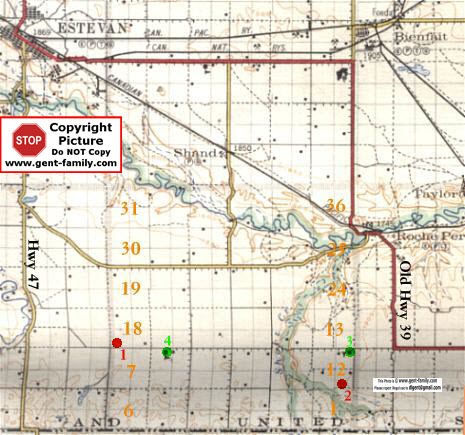
MAP OF ROCHE PERCEE GRAVEYARDS
AS PER SOUTHEAST SASK GRAVEYARD DATA BASE
EMMANUEL GRAVEYARD
AND FOREST GLEN GRAVEYARD
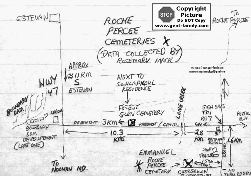
(note-Long Creek in my drawing above is actually Short Creek)
Long Creek became Boundary Dam
THIS IS MY DRAWING ABOVE (1999)
BUT BELOW ARE LINKS TO THE DATABASES
SHOWING THOSE BURIED IN THESE CEMETERIES
THANKS TO ROSEMARY MACK OF BIENFAIT
FOR COLLECTING THIS INFORMATION
Links below in Blue
1927 map below shows these locations better
EMMANUEL GRAVEYARD
SE 1/4 of Sec 12-Tp 1-Rge 7 West Second Meridian
(See map above #2)
IS VIRTUALLY GONE (1999)
THERE IS ONLY HALF A DOZEN HEADSTONES VISIBLE
THE DRIFTING DIRT HAS JUST ABOUT COVERED UP
ALL THE HEADSTONES
IT IS OVERGROWN WITH TREES AND GRASS
IT IS LOADED WITH WOOD TICKS IN THE SUMMER
(I KNOW THIS FROM MY OWN EXPERIENCE!)
IT IS A FAIR WALK IN FROM THE N-S GRAVEL ROAD (1.5KM)
UNLESS YOU HAVE A PICKUP WITH LOTS OF CLEARANCE
AS THE GRASS ISN'T CUT AND THE TRAIL IS NOT USED
no online index at the moment
FOREST GLEN GRAVEYARD
SW 1/4 of Sec 18- Tp 1- Rge 7 W2
(see map above #1)
IT IS NEXT TO THE PAVED ROAD (E/W)
AND IS KEPT UP VERY NICELY
IT IS NEAR THE SCHLAPKOHL RESIDENCE ON THIS ROAD
ABOUT 3 KM E. FROM HWY 47
Note- #3 is the old Brittania School
#4 is another Rural School (name
unknown)
until I read some history about it
no online index at the moment
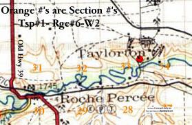
The TAYLORTON CEMETERY
Taylorton records
NE1/4-Sec 33-Tp 1-Rge 6-W2
(red dot in above 1927 map)
was also used by some Roche Percee Residents
It is located South of the old town of Taylorton,
and East of Roche Percee
It exists today in very good condition
thanks to the work of the local residents.
and now a great new site
Sask Cemetery list