NO Reproduction in Whole or in Part, on ANY, and ALL of my Pages,
 Including Text and Pictures,
 May be made, without the express Written Permission
 of Web Editor, Doug Gent
© 2016


My Dad, Phillip George Gent
Phil Gent's (1912-1982)
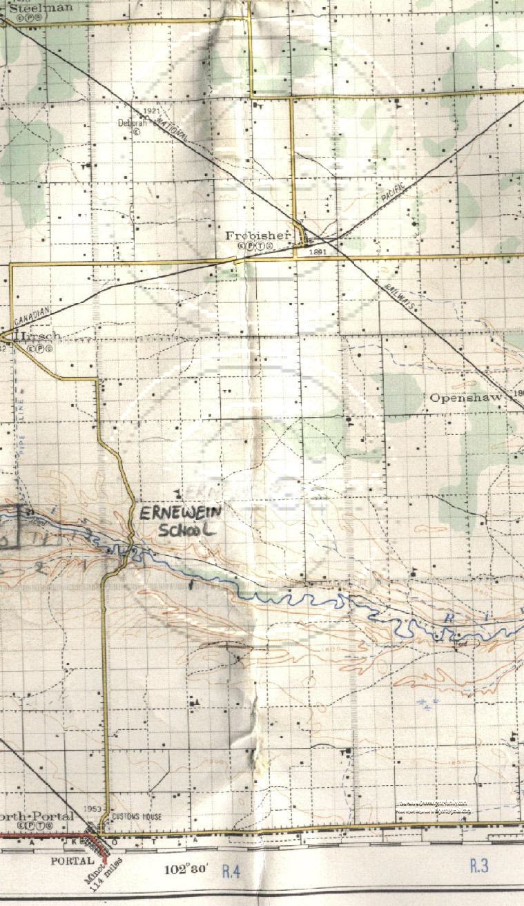
1927
  S.E.  Saskatchewan, Canada
Highway Map


SHOWING TOWNSHIP 1, 2, 3, AND A SMALL PORTION OF 4
IN PART OF RANGE 3, ALL OF 4, AND PART RANGE 5

New* The map on this page has been modified Mar 19, 2010,
with Mouse Over Hot Spots,
on all the Schools, Churches, Towns, Rivers, Creeks, Lakes, etc.
shown on the large map below,
If you "hover" your mouse pointer over any item,
it will show a caption note for that item,
which when "clicked on",
will take you to the name and brief description I show below.
This will help better to identify the Schools and Churches, etc.
 not named on the map.
Note- Some still not identified, or researched.
If you know any of these,
Please let me know which page (URL) and # of the item.

Table below laid out the same way as the Map below

Portion Tsp 4, Half Rge 5, W2

Steelman
I have a web page for
Steelman
Portion Tsp 4, Rge 4, W2 Portion Tsp 4, Half Rge 3, W2
Tsp 3, Half Rge 5, W2

Hirsch
SE 1/4 of Sec 3, Twp 3, Rge 5, W2
Latitude- 49°, 11' 00" N
Longitude- 102°, 36' 00" W
 I have a web page for
Hirsch

Highway 18 in 1927

Tsp 3, Rge 4, W2

Deborah-
 Unincorporated area, 1921 ft Elevation
Section 32, Township 3, Range 4, W2
Latitude- 49° 15' 00" N  
 Longitude- 102° 31' 02" W
Deborah web page

Frobisher,
 Village, 1891 ft elevation
Section 13, Township 3, Range 4, W2
 Latitude-
49° 12' 35" N 
Longitude- 102° 25' 37" W
Frobisher History Book

(Note- Not my web page, link may or may not work)

My Frobisher web page

Highway 18 in 1927

Tsp 3, Half Rge 3, W2

Mayflower School #866
NE 1/4 Section 32 , Township 3, Range 3, W2
John Fraser Moffet
had a homestead grant on this lot
Hjortur Bergsteinsson credited
with forming this school

Highway 18 in 1927


Tsp 2, Half Rge 5, W2

 Pipe Line
 shown heading south of Hirsch
 to the Souris River
was the CPR Water line
to their pumphouse on the river.
This was the water line
for the Steam Locomotives
 used at the time.

Land Owned by my Dad, Phil Gent
marked in Pencil

Souris River
(aka, Mouse River, St. Pierre)


Tsp 2, Rge 4, W2

Ernewein School
SE Sec 17, Tsp 2, Rge 4, W2

Sec 6, Land owned by my Uncle
 Raymond Lee
Just S of the Souris River,
and East of my Dad's land

Souris River
(aka, Mouse River, St. Pierre)
 

Tsp 2, Half Rge 3, W2

Openshaw,
unincorporated area, 1864 ft elevation
Sec 26, Township 2, Range 3, W2
Latitude- 49° 09' 00" N
Longitude- 102° 19' 02" W

My Openshaw web page

Out Of Sight School # 1345,
SE 1/4 Sec 5, Township 2, Range 3, W2
Luke David Thompson, (story above), was instrumental in naming this school
A William Wallace Sr,
born in Scotland
 was one of the main persons
that helped form this school district.
From all records, the school literally
 was out of sight.


Tsp 1, Half Rge 5, W2

North Portal
Village, 1953 ft Elevation
Section 1, Township 1, Range 5, W2
Latitude- 49° 00' 23" N
Longitude- 102° 33' 18" W

North Portal History Book
Historical Map
(Note- Not my web pages, links may or may not work)
 

Tsp 1, Rge 4, W2

McColl School # 2539,
NE 1/4 Sec 12, Township 1, Range 4, W2
James Milne
 had the homestead grant on this lot
It was located on his farm land,
 as his son Albert Milne
 attended this school

Souris River
(aka, Mouse River, St. Pierre)
 

Tsp 1, Half Rge 3, W2

Stony Run School # 1051,
SW 1/4 Sec 15, Township 1, Range 3, W2

Souris River
(aka, Mouse River, St. Pierre)


Common Waterway

Souris River (aka, Mouse River, St. Pierre)
Tributary of the Assiniboine River,
Originates in Yellow Grass marshes, north of Weyburn, SK.
Goes down to Minot, ND, USA, then back up into Manitoba, Canada
ending at the Assiniboine River
.
The mouth of the Souris was the site of Two Rivers School
and a short lived village called Souris Mouth, and/or Two Rivers.

which today, is just a couple miles, NE of Treesbank Manitoba
700 km (435 mi) in length and drains about 17,600 square miles
2 dams are on this river now, Rafferty and Alameda

CNR running from Steelman to Openshaw on this map, NW to SE
CPR running from Hirsch to Frobisher to Oxbow, SW to NE


Reference Key to
Roads, Railways etc.
Reference Key to
Buildings, Altitude etc.
Township Map
Showing Section #'s

`Out of Sight School #1345Ernewein SchoolUnknown School #1OpenshawSteelmanDeborahHirschNorth PortalUnknown School #2Mayflower School #866Unknown School #4Unknown School #5McColl School 2539Stony Run School 1051Water PipelineMy Dad's landMy Uncle Ray Lee's landSouris RiverSouris RiverHighway 18 ca 1927


My Quick Navigation Bar
Choose Your Next Step From Below

Go Back to map Index pageClick this Icon to Return to My Home Index Page at any timeClick this Icon to go to Doug's Email Contact PageClick to Return to the Top of any PageClick to go to Map Page
Page last Updated on:
April 17, 2016
 
Created by Doug Gent
June 15, 2001

No Reproduction in Whole or in Part may be made
without the express Written Permission
 of Doug Gent

© 2016