|
NO Reproduction in Whole or in Part,
on ANY, and ALL of my Pages,
Including Text and Pictures,
May be made, without the express Written Permission
of
Web Editor, Doug Gent
© 2016
Want to add a link to my
pages?
see my
Copyright Information
Page
for the only Authorized Picture Link allowed.
All Pictures on all my web pages, are now Visibly Watermarked,
All my pages are now Right Click, copy and paste, disabled.
I ask everyone that enjoys free history sites,
to start policing these violations.
If we don't stop this, no one will donate pictures to me or anyone,
and we all loose.
If you see one of my pictures on facebook, etc.
tell them to remove it.
|
**
WARNING **
Old
Abandoned Underground Coal Mines can be Very Dangerous,
Due to Collapse, and Mine Gases (Noxious and Flammable).
Extreme Care should be taken around them, due to Falls, Sudden Ground
Collapse, and Bad Air,
and in NO Circumstances should People enter into ANY Mine Openings, or
Associated Caves.
The Material Contained on my Sites,
is NOT to Encourage Personal Investigation of these Mines,
But only as a Historical Record of these Long Abandoned Mines.
Please View these Mines from a Far, Safe and Legal Distance.
Always Observe Private Property Rights, and Obey ALL Warning Signs.
************************************************
|
This is a
Common Page to Five of my sites
Bienfait, Estevan, Pinto, Roche Percee and Taylorton.
When you return to your Village, town or city pages after viewing this list,
please pick the appropriate Index page link below, to return to that site.
Return to Bienfait Index Page
Return to Estevan Index Page
Return to Pinto Index Page
Return to Roche Percee Index Page
Return to Taylorton Index Page
Below is my compilation of various history books, census forms, Canadian
and British, Birth & Death Records, UK and Saskatchewan, Cemetery
Records of Rosemary Mack, Canadian Archives material, and various family
histories, from many books, plus my Mom's old scrapbooks, with Estevan
Mercury articles, pictures, Leader Post articles and pictures.
I do not take credit for any of this material, other than the compiling
of it here. Being old history, most over 100 years, I doubt
if it is copyright any more, but if any of the info below is copyright,
and you want to see it removed, please feel free to contact me.
But I hope for the sake of preserving history, this will not happen.
I am not selling this info, I am not profiting in any way on publishing
it here. I am only trying to show all this information in one
place, it took me many hours to accumulate the story for printing here.
I hope you all enjoy it. It is as accurate as I can get it at the
moment. I am sure like everything else I do, there is errors.
I am not perfect. If there is an error, please let me know,
and I will recheck my info, and we will sort it all out. I've seen
lots of so called well researched books, and have found many errors in
them, so I may or may not be wrong. I've noticed the family
histories are the most prone for errors. Usually written by a
granddaughter or grandson, the dates and info passed on, can be fuzzy at
best. I do appreciate their effort to document their family, as an
amateur genealogist, I know what it's like. We all try our best.
If I was paid for this, I would travel the world, to gather the
documents, but for free, this is what you get.
I have found some new newspaper clippings,
which have revised the order and dates quite a bit, on the mines and
work in this area. I have added new pages, with links from this
page or the town index pages.
Coal
Mine History in SE Saskatchewan
First to see the
coal in this area, would have been the Natives in the area.
I don't know if there is any written record of them using the coal though.
Assiniboine, Chipewans, Sioux,
and Cree, all were here,
as early as the 1700's.
Geological terms, this area is part of the Paleocene Ravenscrag formation.
Prior to coal being reported in the area, the
First White Men had a few expeditions into this area.
Two Sons of Pierre Gaultier de Varennes, sieur de La Vérendrye(1685-1749)
or Pierre La Verendrye (Sr.) for short, in 1742, were at least close to this area,
on their way west in search of a western sea, or river that flowed west..
They named the Souris River, the St. Pierre river, after their father.
Earlier in 1731, La Vérendrye left Montreal
with three of his four sons,
Jean-Baptiste, Pierre, and François, and
made it as far as Winnipeg,
before turning south to the Missouri river.
In 1742
Pierre La Verendrye (Jr.)
and one of his other brothers,
came exploring and possibly came into this area.
Again nothing documented that I know of.
Rock engravings at Roche Percee show early dates of
1773, to 1810.
Possibly Hudson Bay Company
fur traders who came through the area.
Again not much recorded, in the way of coal deposits.
The Lewis and Clark expedition, in
1804 was exploring
along the Missouri and its tributaries when some of their party
went north to see the Roche Percee rock formations.
No record of finding coal was reported in their records.
No doubt the sand outcropping drew them there.
All of these early explorers used Native Indians as guides,
as well as talking with them, they learned of various things,
that were important to them, such as Roche Percee.
The Lewis
and Clark trail passes Roche Percée Natural Arch, seen by Lewis and Clark on
June 6, 1804.
Mr. Daniel Corbett corrected me on the above comment, Aug 8, 2016- "Their actual
journal states"- "they
actually visited a place called Roche Percee in Boone
County, Missouri. Also, by June of 1804 the Lewis and Clark expedition was still
in Missouri which is over a thousand kilometres from Roche Percee in Saskatchewan.
Therefore it would have been impossible" Now we know the comment above was
wrong for sure, thanks Daniel for correcting that for me.
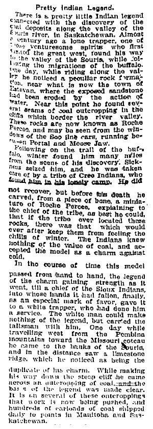
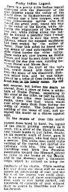
The Native Indian legend below, written about here in 1906, says
a century earlier this story happened, so it seems ca
1806, the coal was seen by this
lone fur trapper. Are those his initials scratched on the walls of the
stone described above? Too bad there is no name here. Wonder what happened to the
carving?
In 1849
Captain John Palliser was near this area,
but not known if he actually made it to see the coal deposits.
It is speculated he did, and the reason he returned in 1857.
The first
"official" written record of the coal deposits came in 1853.
Four United States Railroad surveyors were mapping a route to the Pacific
for a railroad from the Mississippi river, and discovered lignite coal in 1853
along the Souris Valley.
There was nothing done then about the discovery, and their writings.
In 1857 the Palliser Expedition
was sent out by the Canadian Government
to explore that portion of British North America.
They had heard of the Sandstone structure at Roche Percee,
and went 60-70 miles southward from Fort Ellice to see it for themselves.
They reached the Souris Valley on August 21, 1857,
a short distance east of Roche Percee.
a Doctor James Hector (Naturalist)
and Captain John Palliser
were involved.
On the sides of
the valley, a thin seam of lignite coal was exposed.
It was written about, but nothing was ever done.
The
Boundary Commission went through this area
just before the NWMP.
Excerpt from Harper's New Monthly Magazine, Volume 0022, Issue
129 (published February 1861)
Chapter Title: Red
River And Beyond, Page 309,
Author: Marble, Manton states this:
"We had been repeatedly informed by half-breeds (Metis) of the
existence of coal or lignite in strata in the banks of Mouse
(Souris) River, and Saskatchewan. Governor McTavish showed
us pieces of lignite from that river- the first that we had
seen- and confirmed the fact of its existence on the upper
waters of the Mouse (Souris) River. He added that it was used
habitually during the winter at Fort Pitt, and a retired chief
factor, whom we afterward visited, told us that at his former
station, at the Carlton House, it had supplied their
blacksmith's forge."
Chief Factor of Fort Garry, and Governor of the Colony of
Assiniboia, appointed in 1858, was William McTavish, Scotch
birth or descent, per this book. He came to the Bay in
1833, becoming Chief factor at York Factory at one point. He
moved to Red River from York factory in 1857.
b-1815 in Edinburgh Scotland, died July 1870, in Liverpool
England of TB.
Manton Marble (1834-1917) was a New York journalist. He was the
proprietor and editor of the New York World from 1860 to 1876.
In 1859, he went
to the Red River Valley as The Evening Post's correspondent,
contributed 3 articles to Harper's magazine, one of which is
above.
On July 24, 1874, the North-West Mounted Police,
on their march west,
camped at Short Creek, and burned Lignite coal in their campfires, and
forges. Still nothing was done about these discoveries and records. Lots written
about the coal, but still no real mines.
Major James Morrow Walsh was in
charge of D troop, and he later returned to the area, setting up the
Dominion Coal Company,
the first Big Company Coal Mine at Estevan.
Dr. George Mercer Dawson in a
1875 published report
commented on the rocks at Roche Percee. He said "they owe their curious
forms to the weathering away of soft sand from the bed of hard rocks, which is
rendered durable by an abundant calcareous cement."
Dr. G. M. Dawson was born Aug 1, 1849, in Pictou, NS. In 1873 he was
appointed geologist and botanist to her Majesty's North American Boundary
Commission. He mapped the Tertiary Lignite Coal which was originally noted by
James Hector during the Palliser Survey of the 1850s. Dr. Dawson died Mar. 2, 1901, after becoming sick in his Ottawa office 2
days earlier. He was the son of Sir John William Dawson. He attended the
Royal School of mines in London for his training.
Sept 28, 1876
Here we see in writing that the coal
in the area was well known.
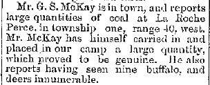
Nov 27, 1879
Mr. G. S. McKay reports on the coal at Roche Percee
Township 1, range 40?, west
He was a bit off on the range?
Seems like a few buffalo still around at that time.
Haven't been able to pin down this fellow's history
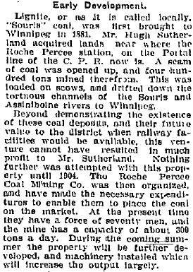
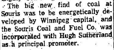
Mr. Hugh McKay Sutherland,
President of the Winnipeg and Hudson Bay Railway and Steamship Company,
from Winnipeg,
came west, with several men
to see what all the excitement was about for himself.
He actually started to ship coal to Winnipeg in the
Spring of 1880, barging the coal
to Winnipeg. Read
Hugh McKay Sutherland's story here.
Jan 27,
1880
The Murdock Party left Winnipeg
to explore the route for the proposed
Government Railway to the Souris Coalfields
Actually left with Dog Trains on this day.
Haven't been able to find more info on this Murdock
May 27,
1880
Thursday Morning, June 10, 1880,
Victoria Daily Colonist printed the story:
Prof. Selwyn of the Geological Survey,
has arrived at Winnipeg en route to study
the geological formation of the Souris Coal Field
Aug 28, 1880
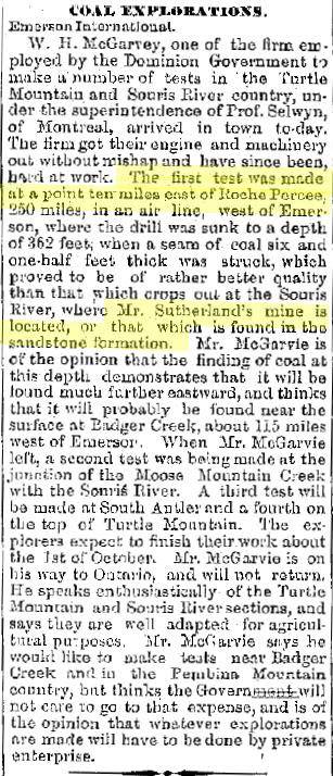
Now we see some serious drilling being done.
Mr. William Henry McGarvey
was hired by the Dominion Government,
and did testing 10 miles east of Roche Percee.
They drilled to 362 feet,
and struck a seam of coal 6 1/2 feet thick.
which they claimed was better quality
than at Sutherland's mine, upstream
at the sandstone outcropping.
see my
Coal
Mines in the Area page
for Mr. McGarvey's bio
Shortly after this he became
probably the world's richest man.
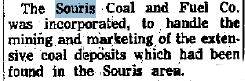
Sept 22, 1880
Hugh Sutherland's Company
The Souris Coal and Fuel Company
was the big player in the game.
Dec 10, 1880
1881, First Coal
brought to Winnipeg
by Hugh Sutherland

Mar 13, 1882
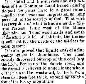
Government Report Minister of the Interior
on Roche Percee Souris Coal discussed
Report is actually for year ending June 20, 1881
The June 1882 discovery, is the
story of the two Pocock brothers,
who came to the Souris (Mouse, St. Pierre) River to shoot non-existent buffalo.
Coming from England, they were told buffalo were everywhere on the plains.
During their "hunt", they encountered some of the main coal seams.
I've added my complete revised
Pocock Brothers Story here.
The big problem,
even though they all knew the coal was here, was the way to get it out.
Wagons were used locally, but not good enough for major mines. River was
not high enough at all times, so water transport was ruled out by Mr. Hugh
Sutherland's attempt. that left the railroad, and until the Manitoba
South-Western Railroad extended to here, nothing was to happen, other than local
farmer sales. When this railroad was sold to the CPR, the extension was
made, and the rest is history. Now they had a relatively cheap way to
transport the coal to Winnipeg, and points east. Strange as it sounds, but
most of this early coal for years went east, virtually none was used in
Saskatchewan. Regina being closer, did not get a lump of this coal.
Seems strange to me, how about you. these mines were controlled from
Brandon and Winnipeg, and that is where the coal went.
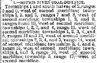
Oct 22, 1883
Souris River Coal District is outlined.
May 19, 1889
It was reported that the Canadian
Pacific Railway Company
has agreed with the Canadian Government
to build a branch line from Brandon southwest
100 miles to the Souris coal district,
and also an extension of twenty-five miles
from the present terminus of the
Manitoba and Southwestern Railway
to a junction with the projected Souris branch.
The company gets the usual grant of 6,400 acres to the mile.
Sept 29,
1891
Major Walsh announced the Souris Coal Mines
will be producing Coal shortly
The first Real Productive "Commercial" Coal Mine in this area was
east of Roche Percee in 1891. Shafts as deep as 90 feet down
were dug in that area. The
Hassard Mine was its name,
was owned by Hugh Hassard.
I created the separate web page for this mine, as it is so important to
the history of the area.
Read about
the Hassard Mine here.
His mine was later to become the Souris Valley
Coal Co. mine
in 1895, with a 8ft coal seam. Located on
SE 1/4 of Sec 4. tp2, Range
6, W2nd, east of Roche Percee.
An article I have states there was 2 mines, the Hassard
mine, down below the old stone house, and
Daddy Gow's mine, 1 and 1/2 miles east
of that. The author says both of these mines were working in 1890-1891.
Alex Dunbar was a miner in the Gow mine. This article also states the
first crossing was a bridge 1/4 mile east of the present Taylorton bridge.
it was built they claim in 1892. This would have been the bridge that
washed away in 1904, from another book. It was built while the Soo line
trestle just south of there was being built.
The Price Mine is also
mentioned next to the Hassard mine. The Bio for Mr. Hiiliard Edwin Price is on
my
Coal
Mines in the Area page
Souris Valley Coal Mine was sold to the Taylor
family of Winnipeg
and renamed Western Dominion
Collieries ltd. This is the name that Taylorton
comes from.
One source on the Pocock story,
says it was Jim and Tom Taylorton
that started a mine in 1887. This I have not found anywhere else.
Another
version said The John Taylor Family who came from Winnipeg Manitoba, but
John was only one of seven sons of Richard, and he was appointed to
manage the mine only. Another of Richard's sons was
R.R. Taylor Jr. All of this info comes from a family source,
Kaye Taylor, wife of Delbert G. Taylor, who is the Great-Grandson of
Richard Radcliffe Taylor. Also adding info was Rhonda, Kaye
and Delbert's daughter. I thank them all very much for this update
on history.
Now we know it was named after
Richard Ratcliffe Taylor Sr.
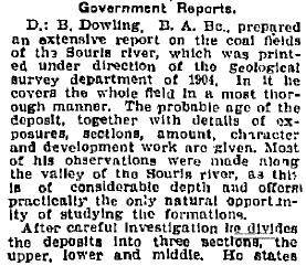
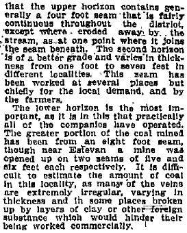
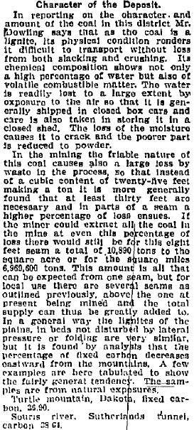
1904 Government
Report by
Donaldson Bogart (Donald) Dowling, B, Ap. Sc.
(b- Nov 5,1858 in Ontario - May 26, 1925)
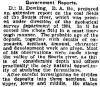
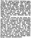
Deep Seam Coal Mining
A mine could not open without the
proper permits. Mine Inspectors from the government were constantly
looking for mines operating without the proper paper work. They also did
safety inspections of the working mines.
First an owner or operator had to
obtain mineral rights for the land. Owning the surface land was not
enough. They had to have a pit boss that would constantly survey the area,
to ensure they were mining on their own property. He was also responsible
for the safety of the mine, width of the pillars left, and properly timbered as
they went deeper.
The best grade of Lignite coal
in this area was about 100 feet below the surface. They dug an entry from
a hillside, on the bank of the Souris River, at a slope, or an angle, down to
reach this seam. Thickness of the seam was up to 14 feet (4.27 mtrs), but
averaging 6-7 ft.. the entry was 8 ft (2.4 mtrs) wide, down to the vein,
then 2 entries were driven into the vein, with 24 ft (8 yds) (7.3 mtrs) wide
rooms at right angles on either side of these. Pillars of coal, 6 ft (1.8
mtrs) wide were left between these rooms to support the roof, and then cross
cuts were made for air circulation. This form of mining was called
the Conventional Room-and-Pillar Method,
also known as Bord and Pillar method in England, was
used in many parts of the world, prior to this area. It is one of
the oldest forms of underground mining known. It creates a grid like
pattern underground. They did not do retreat mining, as was used in some mines
later on. Bord (also spelled board) is another term for a coal roadway, or
side gallery, or room,
It was
probably a system invented in England.
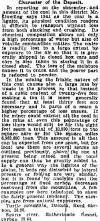
As they dug deeper, air shafts were
dug to the surface to supply air to the mine deep underground. They used a
fan at the bottom of the slope to circulate the air. They used
these fans at noon and evening after they used black powder shot to extract the
coal, to evacuate the thick smoke it generated. Some mines used children
to open and close big doors in a rapid manner, to create air movement.
They used electric cutting and shearing machines later on, which made it a
little safer.
All work was done by the light of the carbide lamp, worn on a cloth hat by the
underground miner. No breathing apparatus, no air quality testing
stations. No real safety equipment of any kind.
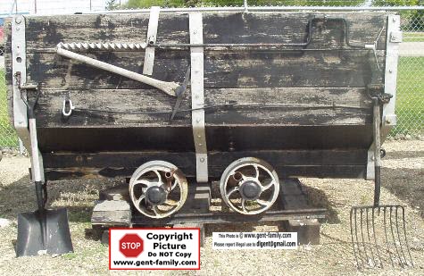
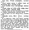
Light rails were laid, and coal was loaded into
mini coal cars, then towed by horses to the bottom of the slope. My dad's
job underground was looking after horses that did this job. The larger
mines used vertical shafts to raise the coal to the surface on a hoist.
They only used the slope for the men to enter and exit the mine. They also
used electric trolleys, rather than horses to tow the cars, which were also
larger than the first mines in the area.
There you have it in a nut shell, the abbreviated version of how the Coal Mines
were developed in SE Saskatchewan, and a very basic description of their
operation method. |
Types of Coal
ANTHRACITE
Highest Carbon Content- 86-98%
15,000 BTU's/LB
BITUMINOUS
45-86% Carbon Content
10,500 - 15,500 BTU's/LB
SUB-BITUMINOUS-
35-45% Carbon Content
8,300 - 13,000 BTU's/LB
LIGNITE
(Also known as Brown Coal)
This is the type of Coal in SE
SASK.
25-35% Carbon Content
4,000 - 8,300 BTU's/LB
The bad side is Lignite is the lowest grade,
the good side, there seems to be lots of it here.
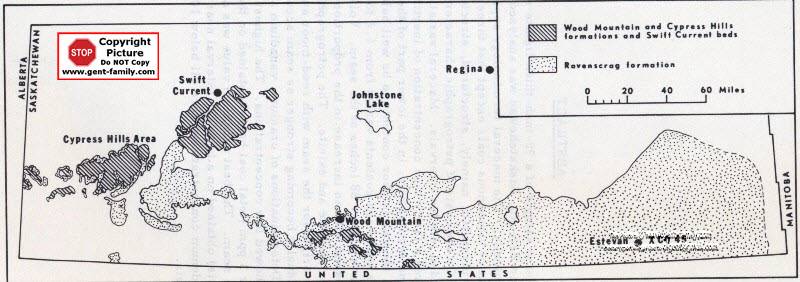
Saskatchewan Coalfields Map
Bienfait/Estevan are part of the Ravenscrag formation
the dotted area in map above
map courtesy Mr. Grant Walker, CA, USA
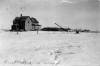
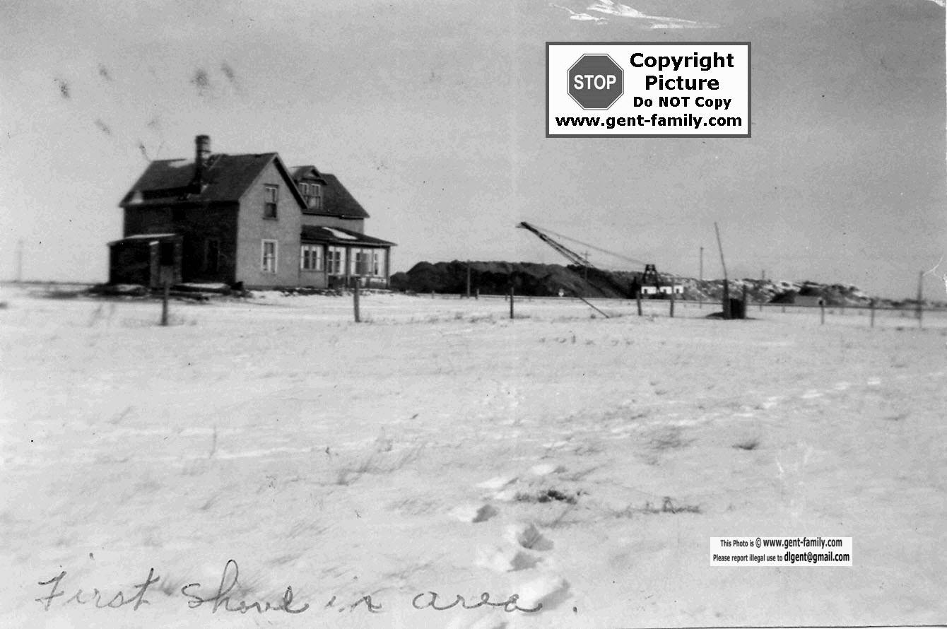
First Shovel in the area of our Farm house
located 1 mile south of Bienfait.
Picture dated Jan 27, 1953
My
Dad's Story, as remembered by myself
My dad started working in the coal mines in 1931.
He was working in the coal industry
until 1977 when he retired, age 65.
His first job was hauling coal with horse and wagon,
and hand shovelling it into a Box Car at the siding in Roche Percee.
He started at the Eastern Collieries later in 1931.
He supplied a horse, and hauled coal with a dump cart for .28 cents/hour
In 1933 he started working underground,
driving and working on coal cutting and shearing machines.
In April when the tipple burnt down,
He was one of three men that filled the shaft with two wheelbarrows.
Later he worked at the Wilson #2 mine.
After that he returned to the eastern mine
to work on rebuilding the new Tipple.
In 1958 he started to work at Utility Coals,
until he retired in 1977.
He was in charge of the horses
underground ,
that were used to haul the coal-cars
from where the cutting machine
was,
to where the coal was hauled
up to the tipple.
He told many stories of these
days,
and it is too bad VCR's and Camcorders
were not around in the 70's
to record these for future generations.
Some of the stories I remember
are the fact that the horses
were taken underground
and never brought up until they
died.
If they were to be brought to
the surface they would go blind, from the sunlight.
My Dad loved these horses as
much as he loved us, I am sure.
He used to tell us how
the brakes would fail on the ore car
and literally run down, and over
the horse,
and all the bosses would say
is
"get another horse and get working"
.
No down time for a crippled or
dead horse!
Same would happen when a man
died underground,
it was work as usual shortly afterwards.
Dad used to tell us the dead
or injured man
would be brought to the surface
on a grain door.
No fancy stretchers or first-aid
men here.
My Dad told us he had many close
calls,
and danger lurked around every
corner.
The only difference was if the horse died,
there was lots of explaining to do to the boss,
as they cost money to buy.
There was 100 men around the corner to replace a dead one.
Years later on hearing of an
underground explosion
and men trapped my Dad would get
a tear in his eye
and I am sure a little prayer
was said.
The Coal miners stick together
even after coal mining!
Stories have been told,
and songs have been sung about
the company store,
but looking at the pay stub below,
you can see they were all true.
A miner had to buy his own carbide
to light his lamp underground.
Tool rental was charged to dig
the Coal for the company.
Prices were outrageous and if
you didn't buy at their store your
job was in jeopardy, and also your company housing.
He would tell us the story behind
the miners strike that ended up
with the RCMP killing 3 miners
on Sept 29, 1931.
These miners are buried in the Bienfait cemetery,
and every so often a yellow stripe
is painted
on the tombstones to show the
RCMP involvement.
This same stripe gets scrubbed
off every so often
by police sympathizers.
The Library in Bienfait has a
very good video,
that all interested in this era
should view.
I believe it was produced
by the CLC.
It has both perspectives in it.
Interviews with the Police Chief
in Estevan at the time,
and also interviews with miners
from that era.
It shows the living and working
conditions of the miners.
The cheating on the pay. Most
miners were paid by the hour,
but some I guess were paid by
the Coal-car load,
(they had to load the car by
hand)
and were paid by the weight of
the Lignite coal they loaded.
The person weighing the
coal was management,
(or in bed with them),
and would say the weight was
less than it actually was.
Another way for the company
to shaft the men.
A definite must see!
Wonder why there is Unions today?
Today you can see depressions
in the ground
between Estevan and Bienfait
and most of these
would be underground cave-ins
from these old mines.
Just before my Dad died, he was
called upon
to identify old mine locations
to the authorities,
so these could be looked at.
Cave-ins could be very dangerous,
and over the years people have
climbed into old mines etc.
and have been buried alive.
Recently I believe some children
were involved.
Today there is not many alive
who know where these mines were,
so they can be checked and dismantled,
to eliminate the danger.
The mines took their toll on my
Dad's life, and over the years he
had an operation on his diaphragm,
and also had other
breathing difficulties. It definitely
shortened his life.
I feel sorry for those that endured
the same fate.
Years ago, in Estevan, they started
to recognize
the "old" miners of the area, and
a "Lignite Louie"
was chosen each year. I hope
this has continued today.
Oil became the resource in the
50's & 60's,
and Coal mining was their poor
cousin.
Thank God for people like Mr
Leonard Gadd, Mr Souther,
and now the Walliser family, who worked at,
and helped maintain the Little
Museum in Bienfait,
devoted almost totally to this
way of life.
I am sure people who live
in Estevan haven't been there.
What a shame. Schools should
be taking trips down there
to see this display.
Without the Coal the people might
not have even settled there.
The farmer those days barely
made a living
and without the coal mine would
have barely existed.
Would the train have come to
this area? I doubt it.
Would the Power Plant that feeds
electricity to that area exist?, No.
I could go on and on.
We owe a huge debt to Coal and
the Miners who worked with it.
As an aside to the Power plant
and acid rain issue,
I remember as a kid seeing nothing
but white alkali soil everywhere,
nothing would grow near any slough,
but today all sloughs are green
and lush and loaded with ducks.
Some areas need a little acid to balance
the PH,
and I think this is one. I am no Geologist
etc. but it
does not look like it is hurting
this area too much anyway.
There is so many environment issues today
that emissions are much reduced from the past.
The reclamation of the land is
much improved
also so if it has to be mined,
they seem to be doing it right.
We need jobs, we need power,
so not much you can do.
A hell of a lot better
than nuclear in my eyes!
My dad saved some of his mining
equipment
and today I have those in my
possession,
and these will be handed down
to my son to be passed
down to his offspring maybe some
day.
I love to show this material
to people
and am very proud of my dad and
his involvement.
I have his carbide lamps, plus
Dad's first " hard hat" that wouldn't
save too much of anything, but
keep coal dust off your hair!
It is made out of a type of press
wood
that you see in cheap bowls today.
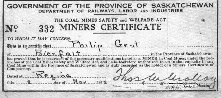
This is a copy of my
Dad's "Miners Certificate"
from 1932
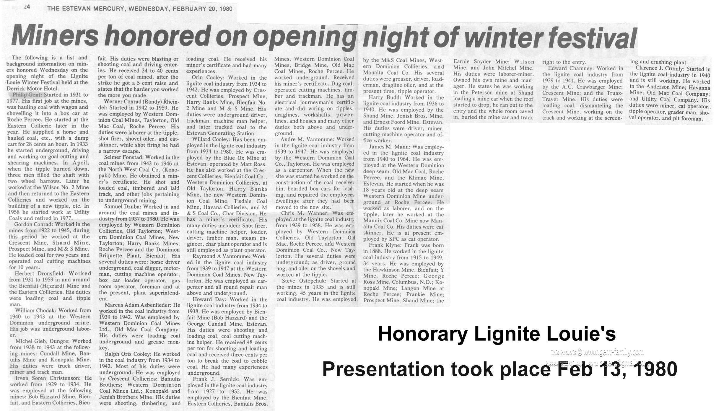
Below is the Feb 20th, 1980 article from the Estevan
Mercury
showing my dad and others being honoured,
by naming them Lignite Louie's on Feb 13th, 1980.
A Proud Moment for my Dad, no doubt.
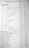
List of Honorary Lignite Louie's in 1980
Phillip George Gent, Gordon Conrad, Herbert Dronsfield, William Chodak,
Michael Gieb, Irven Soren Christenson, Werner Conrad Rheindel,
Selmer Fonstad, Samuel Dzuba, Marcus Adam Asbenlieder,
Ralph Orie Cooley, Orin Cooley, Willard Cooley, Raymond A. Vantomme,
Howard Day, Frank Sernick, Andre M. Vantomme, Chris M. Wanner,
Steve Ostepchuk, Harry B. Budd, James M. Mann, Frank Klyne,
Edward Chamney, Clarence Crumly
When you return to your Village, town or city pages after viewing this list,
please pick the appropriate Index page link below, to return to that site.
Return to Bienfait Index Page
Return to Estevan Index Page
Return to Pinto Index Page
Return to Roche Percee Index Page
Return to Taylorton Index Page
Check out my compilation of
Names and Locations of Coal Mines in the area.
Coal
Mines in the Area
Links below are not my sites, and may or
may not work Interested in the geology of the area?
http://earthnet-geonet.ca/vft/sask/rwe/stop6_e.php
Resource map of
Sask.
http://www.ir.gov.sk.ca/resourcemap
Encyclopaedia of SK
http://esask.uregina.ca/entry/coal.html

Coal Mine Index Page |