TAYLORTON
SASKATCHEWAN
CANADA
Main Index Page


    Site Index

Postmasters
Taylorton Cemetery
Old Taylorton Pictures (2)
Taylorton School Pictures
Luscar Ltd History Pictures (5)
Joseph James Photos, ca 1928

Taylorton Pictures Year ?
Taylorton Pictures 1987 (2)
Taylorton Pictures 1999
Jane McElwee Story
Taylorton 1927 Map
Twigger Family (new 2013)
Edwardson Family (new 2013)

Coal Mine Info
SE Saskatchewan Coal Index Page (new)

Note- All Coal related Links
are now combined
and revised in this new
SE Saskatchewan
 Coal
Index Page above

-----------------------------
Quick Area Links

Estevan
Bienfait
Pinto
Roche Percee
-----------------------------
RM #4 Coalfields
----------------------------

General SK. Info.
SE SK. Index Page
-----------------------------
Personal Home Pages
Recent Changes to this Site


 NO Reproduction in Whole or in Part, on ANY, and ALL of my Pages,
 Including Text and Pictures,
 May be made, without the express Written Permission
 of Web Editor, Doug Gent
© 2016

Want to add a link to my
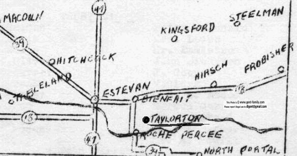
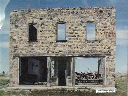
 pages?
see my
Copyright Information Page
for the only Authorized Picture Link allowed.
All Pictures on all my web pages, are now Visibly Watermarked,
some are Semi Invisible, and most now have Secret Watermark,
And some have all 3 !
All my pages are now Right Click, (copy and paste), disabled.
If this unauthorized use of pictures from this site continues,
I will remove the whole thing,
 as there is no point in keeping it online.
I ask everyone that enjoys free history sites,
to start policing these violations.
If we don't stop this, no one will donate pictures to me, or anyone,
and we all loose.
If you see one of my pictures on Facebook, etc.
tell them to remove it, if they don't in a reasonable time,
please email me the culprit,
and I will add them to my
Wall of Shame page.
Trust me, I regret having to do this!


TAYLORTON WAS FIRST CALLED
"COALFIELDS"

Exact Location
Township (TSP) (N-S)= 2
Range (RGE) (E-W)= 6
Meridian= W OF THE 2ND

Located in RM#4 Coalfields
It is located 8 miles SE of Bienfait SK
In the SE corner of Saskatchewan Canada

The First Post Office in the area
 was called "Coalfields"
It originated around 1890 in the Valley
It later in 1905, became "TAYLORTON"
When the Hamlet and Post Office 
was moved up out of the valley,
onto the flat Plain above.
My 1927 map shows this location

Origin of the Name Taylorton?

It was Named after the Owner of the Mine


Richard Ratcliffe Taylor (Sr.)


His Bio can be found here

Richard Ratcliffe Taylor Bio


 ** WARNING **
 Old Abandoned Underground Coal Mines can be Very Dangerous,
 Due to Collapse, and Mine Gases (Noxious and Flammable).
 Extreme Care should be taken around them, due to Falls, Sudden Ground Collapse, and Bad Air,
 and in NO Circumstances should People enter into ANY Mine Openings, or Associated Caves.

 The Material Contained on my Sites, is NOT to Encourage Personal Investigation of these Mines,
 But only as a Historical Record of these Long Abandoned Mines.
 Please View these Mines from a Far, Safe and Legal Distance.
  Always Observe Private Property Rights, and Obey ALL Warning Signs. 
   ************************************************ 


Taylorton over the years, consisted of: 
a Church, School, Tipple, Garage, Mine Office, Outdoor Skating Rink,
  Butcher Shop, Post Office, Store, and Boarding House. 
There was about 30 houses on the Prairie, top of the hill, 
and about 35 in the Valley.  When it was in it's first location
 in the valley, called "Coalfields" 
The Hamlet was located where the Souris Valley Mine was, 
Which was the Hugh Hassard Mine. (first mine in the area) 
The Hamlet was moved again to a location near old highway 39. 
Map on the Estevan web site shows this location. 
Most of the houses it seems were painted Green and White. 
The residents worked for The Western Dominion Mines Ltd. 
Total population it seems never exceeded about 300 persons. 
There was, and still is, a Cemetery located on
 the edge of the Hill  It has been fully restored and in 1999
was in very good condition. 
A huge wrought Iron gateway has been erected at the entrance. 
Not much is left of the entire Hamlet, other than some stone remains
 of the store, and the Cemetery. 
The whole area of the Hamlet, is now a Restricted area, 
with NO TRESPASSING signs posted by the
present Mine Company Owners. 
These signs should be respected for your safety, 
as under this whole area, is old underground mining operations, 
and cave-ins are quite prevalent, 
and could cause Serious Injury and/or Death!. 
Please view the area through Binoculars, or Telephoto lens only!


The following are links to other sites
They are NOT mine.

COAL MINER'S STRIKE  SEPT 29,1931
http://library.usask.ca/sni/stories/con13.html
NOT MY SITE!


OLD SASKATCHEWAN MAPS
http://www.rootsweb.com/~canmaps/
NOT MY SITE!


No Reproduction in Whole or in Part may be made
without the express Written Permission
 of Doug Gent

Page created by Doug Gent © 2016
Created Dec 6, 2000

Revised Nov 26, 2011

Quick Links
Personal Family Pages
SE Sask. Web Pages / Dad's 1927 Map of SE Sask. / Hillside Public School
Estevan Collegiate Institute / Nor-West 1904 Newspaper / Terrace BC
BC Tel Terrace District History / Contact page

View the Feedback I get on my Taylorton Pages
Click Here