NO Reproduction in Whole or in Part, on
ANY, and ALL of my Pages,
Including Text and Pictures,
May be made, without the express Written Permission
of Web Editor, Doug Gent
© 2016
Want to add a link to my
pages?
see my
Copyright Information
Page
for the only Authorized Picture Link allowed.
All Pictures on all my web pages, are now Visibly Watermarked,
All my pages are now Right Click, (copy and paste), disabled.
I ask everyone that enjoys free history sites,
to start policing these violations.
If we don't stop this, no one will donate pictures to me, or anyone,
and we all loose.
If you see one of my pictures on Facebook, etc.
tell them to remove it.
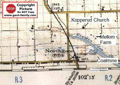
Northgate Saskatchewan
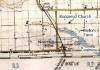
Part of my Dad's 1927 map
click to enlarge
Located on the North side of the US/Canada
Border
just East of Saskatchewan Highway #9
On Section 6, Township 1, Range 2, West of the
2nd Meridian
Latitude- 49° 00' 00" N
Longitude- 102° 16' 02" W
1841 ft elevation
Part of RM of Enniskillen #3
named after a place in Northern Ireland
Northgate came into being
with the coming of the Grand Trunk Pacific Railroad Oct 14, 1913
connecting Northgate to Regina SK., see below
Northgate at various times in it's history,
hosted a Post Office, Grocery Store,
Customs and Immigration Offices, Railway Station,
Train Round House, Railway repair shops,
Quarantine Barn, and Pens,
a School, a Hotel, and of course homes.
I remember the store, as in the mid 60's
I was a swamper on the Grundeen Creamery
delivery truck from Estevan.
Northgate store was our 2nd last stop.
North Portal was our last stop before heading back to Estevan.
This was a full day delivery, from before dusk, to after dark.
First
Junior Red Cross Society in the World
was created here Oct 7, 1915.
Customs
CBSA Agency, Canada Customs Office #613, at Northgate
Link
to their web site- note not my site, link may or not work
School
Northgate School District #4006
Northgate Post Office
Locations of the
Post Office
SE 1/4 Sec.6, Twp.1, R.2, W2
Sec.6, Twp.1, R.2, W2 - 1914-07-01
Store
Federal
Electoral District:
Moose Mountain
(Saskatchewan)
Opened July 1,
1914
|
Name of
Postmaster |
Date of
Appointment |
Date of
Vacancy |
Cause of
Vacancy |
|
Miss Agnes
Mygaard |
- |
- |
Cancelled |
|
Miss Ethel
Williams |
- |
- |
* |
Henry Edward Hinsvark
b- July 1873 in Decorah, Iowa, USA,
immigrating to Canada in 1903
Norwegian nationality, Lutheran,
Occupation Farmer in 1911
Wife- Mary Hinsvark, nee ?
b- Aug 1882 in Maine USA
children, Simone, Bernice, Louisa |
1914-07-01 |
1919-06-16 |
Resignation |
|
Mrs. H. C.
Thompson |
1919-07-30 |
1929-06-08 |
Resignation |
Mrs. Eva
Caroline Lees
b- 1880 |
1929-09-25 |
1931-07-13 |
Resignation |
Miss Freda
Winnifred Robertson
married a Mr. Swenson, see next entry |
1931-12-09 |
1934-01-31 |
Resignation |
Mrs. Freda
Winnifred Swenson (Re-appointed)
obviously nee Robertson above |
1934-05-30 |
1940-08-10 |
Resignation |
|
Mrs. Merle
Virginia Robertson |
1940-09-08 |
Acting |
- |
|
" |
1940-10-04 |
1943-01-22 |
Resignation |
|
Mrs. Annie
Junas |
1943-01-31 |
Acting |
- |
|
" |
1943-03-12 |
1943-11-08 |
Resignation |
|
Mrs. Ethel
Geraldine Olsen |
1943-11-23 |
Acting |
- |
|
" |
1944-02-24 |
1945-10-25 |
Resignation |
|
Dalbert
Harold Friedrick |
1945-10-31 |
Acting |
- |
|
" |
1946-04-18 |
1977-07-01 |
Retirement |
|
Mrs. Linda D.
Jones |
1977-07-01 |
- |
- |
Source- Library and Archives Canada
This reproduction is not represented as an official version
of the material reproduced
or as having been made in affiliation with,
or with the endorsement of,
Library and Archives Canada
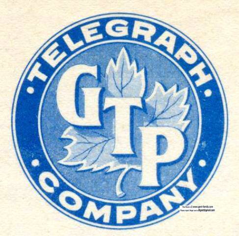
Grand Trunk Railway
Brief History
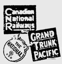

GTP Telegraph Company Logo, 1916
Photo courtesy Grant Walker
Originally this area was
located on
the Grand Trunk Pacific Railroad (GTPR),
a subsidiary of the Grand Trunk Railway,
referred to as the "GTPR
Regina Boundary Branch Line"
GTPR station at Elev 1841 ft
Railroad built by
Grand Trunk Pacific Branch Lines Company (GTPRBL)
which completed the connection,
to Prince Rupert BC from Chicago.
This Railroad connected at Northgate* SK.,
with a new branch line from Niobe, ND.,
built by the Great Northern Railway.
(*note some old newspaper articles called it Northport)
Feb 6, 1912
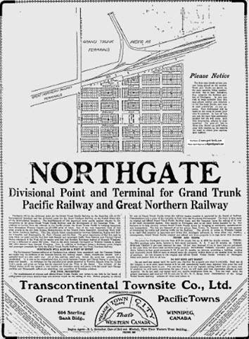
Seward T. St. John** of the Transcontinental Townsite Company Ltd.,
located at 268 Portage Ave. Winnipeg MB.,
and also shown as 604 Sterling Bank Bldg., Winnipeg MB.,
who was in charge of the GTP Development Department,
announced the building of 15 new towns,
on the Regina Boundary Line.
A contract had been awarded to a Minnesota firm,
to build General Stores in various towns along the line.
They wanted to make sure the area the train went thru
would be well served and used by the settlers.
They had picked the following names:
Innes, Cedoux, Huntoon,
Rainton, Beliot, Sander,
Minard, Breeze, Steelman and Deborah.
The Post Office required a name that was not the same
as any other town in Canada at the time.
Trains #7 and #8, left Regina at 1pm, Mon, Wed, and Fri.
arriving in Regina Tues. Thurs, and Sat. in 1914.
Times changed a little bit a few years later.
1923 this all became part of the CNR
**Seward Thaddeus St. John
b- Apr 20, 1865 in Eldora, Hardin Co., Iowa
d- ?
shown as a homesteader at Wilcox SK, 1901
also shown as Real Estate Agent there when he was
a shareholder in the Canadian Central Railway Company.
1900 living in Omaha City, Douglas Co., Nebraska, single
father- James McKie St. John, b- ca 1831 in NY
mother- Diantha Ellsworth, b- ca 1838, in PA
He married Stella Wilson, June 29, 1900
she was born in Roseland, Adams Co., Nebraska
Mar 17, 1913,
An article stated 600 men will
be working on this line that summer.
Branch expected to be in operation end of 1913.
Steel was already laid for 106.9 miles to Hill Hall.
grading was done as far as Frobisher, 136 miles from Regina.
and 90% of the grading was done to the border from there.
Saturday
Sept 6, 1913
Government Railway Inspector,
approved the line for use.
Vice President and General Manager of the GTPR,
Edson Joseph Chamberlin***, was expected
the next Thursday or Friday to officially inspect the line.
***Edson Joseph Chamberlin
b- Aug 25, 1852
Lancaster, New Hampshire, USA
d- Aug 27, 1924 in Pasadena CA
May 24, 1912 he
became President of the Company
after Charles M. Hays died on the Titanic in 1912.
Sept 1917 he resigned, and remained as Director.
Howard G. Kelley moved up from Vice- to President.
Dec 4, 1913
A Grand Trunk Special train of Regina Business men
with train executives, were the first to travel on this line.
Early 1914 lots were being sold in the
new Village
Mr. G. U. Ryley**** was Land Commissioner for the GTPR
They named a village in Alberta after him.
http://youtu.be/S76zYv_YbaA
He was in Winnipeg at this time
but I believe he was from Ottawa, married
This was the guy that named all the towns/stations
Corrections to Mr. Ryley sent Jan 8,
2015
Hopefully I now have the correct info below
This is a
Biography of G. U. Ryley
via the Association of Ontario Land Surveyors
http://www.aols.org/sites/default/files/Ryley-G.U.pdf
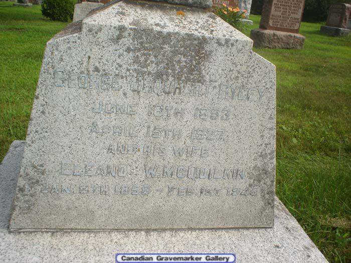
****George Urquhart Ryley
b- June 16, 1853 in Hamilton, ON
d- Apr 16, 1927 in Ottawa, ON, age 73
buried in Beechwood Cemetery, Ottawa, ON
photo courtesy Beechwood Cemetery,
via person that sent corrections
George
married Eleanor Wallace
McQuilkin
Apr 14, 1881 in Toronto, York, ON
b- Jan 8, 1858
d- Feb 1, 1945
daughter of Samuel and Kate
McQuilkin
George's
father- John Proud Ryley
b- July 1, 1825, in Birmingham England
mother- Elizabeth "Eliza" Jane Ryley, nee Urquhart
b- ca 1836 in Kingston, ON, age 45, in 1881
Eliza's paternal grandmother was from the Drouillard family
that settled in 1700s at Fort Ponchartrain of New France
which is now the Windsor-Detroit area.
Eliza's paternal grandfather was from the Urquhart family of Scotland.
G. U.
Ryley's address was 644 Rideau St. Ottawa, Ontario at the time of his death
3 younger siblings of George:
Edmund U. Ryley- b- ca 1857 in ON, shipping agent
Alfred Golde Ryley- b- ca 1859 in ON, accountant
May Dickenson Ryley- b- ca 1871 in ON
2 children born in Ottawa
1881- Surveyor, living in Collingwood, Simcoe N, ON
George had land grants on Sec 28 and 30,
Tsp 71, Rge 3, Meridian 6
Top of map shown, is West, North is
right side of page
Street names assigned:
North-South from Railway Ave East
Canada Ave.
Northern Ave.
Western Ave.
Prairie Ave.
Pacific Ave.
Dakota Ave
School/ Public land in the middle
East-West
from South side
Boundary St
(Actual Canada American Border,
South is USA, North is Canada
All streets below surveyed in Canada)
King St.
Centre St.
Queen St.
Saskatchewan St.
2005
CNR discontinued the Minard to Northgate spur line
claiming it wasn't used for 3 years prior to that.
found a 1926 article that stated Regina
boundary branch
in 1912 107.27 miles was built, then 1913, 46.94 miles
and in 1923, 2.00 miles on Lampman connections
abandoning 1.44 miles of old line.
Hill of the Murdered Scout- Scout Hill
Scout Hill History and Map